
- NAEI
- Data
Data

Latest LRTAP/NECR Submissions
Historical Air Quality Emissions Data (Updated Annually)
- Annex I: Sectoral UK Emissions for 1990-2022 (2024 Submission)
Methodology Documentation (Updated Annually)
- Informative Inventory Report: 1990-2022 (2024 Submission)
Projected Air Quality Emissions Data (Updated Annually)
- Annex IV: Projected UK Emissions for 2025-2050 (2024 Submission)
Gridded Emissions Data (Updated every four years)
- Annex V: Gridded Emissions data for 2019 (2021 Submission)
Large Point Sources Emissions Data (Updated every four years)
- Annex VI: Emissions from Large Point Sources for 2019 (2021 Submission)
Historic submissions are available in the Submission Archive.
UK emissions data selector
![]() Download UK emissions data: by Air pollutants, Greenhouse gases, Heavy metals, Particulate Matter
Download UK emissions data: by Air pollutants, Greenhouse gases, Heavy metals, Particulate Matter
Download emission factors
Emission data in Pivot Table Viewer
- Air Quality data (XLSX)
- Greenhouse Gas data (XLSX)
Historic pivot tables are available in the Pivot Archive.
UK Emissions Interactive Map
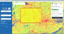
A user-friendly interface of the UK emission maps which allows the users to explore and interrogate the data at a variety of scales and perform data queries using simple click and select buttons.
The Data section of the NAEI website allows you to find and download emissions data from the NAEI.
UK emissions statistics from the NAEI form part of the National Statistics, published by Defra and BEIS on an annual basis. Statistics related to air quality emissions can be found on Defra's website and statistics for greenhouse gas emissions can be found on the BEIS website.
National Statistics publications do not include all pollutants within the NAEI. For emission data for the full range of pollutants, please see the UK emissions data selector.
Use the links on the left to find the datasets you are looking for.
Licensing
Information on naei.beis.gov.uk is published by Defra, BEIS and the Devolved Administrations under the Open Government Licence (OGL) and subject to the terms described in the "licence" or "constraints" of the OGL, except where otherwise noted. Under the OGL you are free to:
- copy, publish, distribute and transmit the information
- adapt the information
- exploit the information commercially and non-commercially for example, by combining it with other information, or by including it in your own product or application
You must, where you do any of the above, acknowledge Defra, BEIS and naei.beis.gov.uk as the source of the information by including the following attribution statement in reports, web pages or derived data products and, where possible, provide a link to the OGL licence.
© Crown 2024 copyright Defra & BEIS via naei.beis.gov.uk, licenced under the Open Government Licence (OGL).
For Northern Ireland only: This is Crown Copyright and reproduced with the permission of Land & Property Services under delegated authority from the Controller of Her Majesty's Stationary Office © Crown Copyright and database right 2017 INSP594.
Ordnance Survey of Northern Ireland (OSNI) branded Land & Property Services (LPS) mapping (or any mapping based on, or derived from OSNI branded mapping) is exempt from the terms of the OGL.
If you intend to use or re-use this information you need to apply to copyright@dfpni.gov.uk for an appropriate licence.
Page last modified: 14 March 2024